

(From the General Office of the CPC Central Committee and the General Office of the State Council)
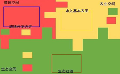
In order to coordinate the delimitation and implementation of the Ternary Control Lines (TCLs), in terms of Ecological Protection Redline (EPR), Permanent Prime Farmland (PPF), and Urban Development Limit (UDL), the following opinions are hereby put forward.
1.General Requirements
(1)Guiding Ideology
Follow the guidance of Xi Jinping’s Thought on Socialism with Chinese Characteristics for a New Era, fully implement the guiding principles of the 19th CPC National Congress, thoroughly implement Xi Jinping’s Thought on ecological civilization, and implement the decisions and plans by the CPC Central Committee and the State Council, in terms of the strictest systems for ecological environment protection, farmland protection, and land conservation, we take the TCLs as insuperable redlines for adjusting the economic structure, planning the industrial development, and promoting urbanization, and lay a solid foundation for the sustainable development of the Chinese people.
(2)Basic Principles
a)Bottom-line Thinking, Protection First
Based on the Assessment of the Carrying Capacity of Resources and Environment and the Suitability of National Territory Spatial Development, we should scientifically and orderly make overall planning for ecological, agricultural, and urban areas, strengthen bottom-line constraints, and give priority to ensuring ecological, food and national territory security.
b)Multiple Planning in One, Coordinated Implementation
Following the requirements of unified base map, unified standards, unified planning, and unified platform, we scientifically delimit and implement TCLs to avoid intersecting, overlapping, and conflicting.
c)Overall Proceeding, Classified Controlling
Insist on land-sea integration, upper-lower levels linkage, and regional coordination. We establish and improve category-based control mechanisms for the TCLs, based on their respective functions, considering different natural resource endowments and economic and social development conditions, in different regions.
(3)Job Objectives
By the end of 2020, in conjunction with the formulation of National Territory Spatial Planning (NTSP), the TCLs shall be delimited and settled. Conflicts shall be resolved coordinately. TCLs shall be incorporated into a basic territorial space information platform with national unity and Multiple Planning in One, forming a base map for information sharing among government departments with strict management and control. By 2035, with strengthened implementation management of the NTSP, we strictly obey to the TCLs, guide the formation of a scientific, appropriate, and orderly system for the distribution of national territory space.
2.Scientific and Orderly Delimitation
(4)Formulate the EPR Based on Ecological Functions
The EPR refers to the areas within the ecological space and with special and important ecological functions and must be imposed with compulsory strict protection. Priority will be given to areas with extremely important ecological functions such as water conservation, biodiversity conservation, water and soil conservation, windbreak and sand-fixing, and coastal protection, as well as areas with extremely sensitive and fragile ecology such as soil erosion, desertification, rocky desertification, and coastal erosion. Other areas with potentially important ecological value, though uncertain after assessing, are also should be included into the EPR. Adjust and optimize the Nature Conservation Areas (NCA), after which have been adjusted and assessed, should be included into the EPR. Where NCA is adjusted, EPR should be modified accordingly. Within the EPR, human activities are prohibited in principle in the core protection areas of NCA; development and productive construction activities are strictly prohibited in other areas. In accordance with existing laws and regulations, except for major national strategic projects, only limited human activities which do not damage ecological functions are allowed, mainly including: the repairing of their production and living facilities and the retaining of a small amount of planting, grazing, fishing and breeding necessaries for life by the original inhabitants, on the premise of not expanding the existing construction land and arable land; strategic energy resources exploration for the country's major energy and resource security, natural resources investigation and geological exploration for the public; natural resources and ecological environment monitoring and administration, including hydrology and water resources monitoring, investigation and punishment of water-related violations, disaster prevention and control, and emergency rescue activities; non-destructive scientific research observation and specimen collection approved by law; archaeological investigations and excavations and cultural relics protection activities approved by law; moderate tourism and construction of related necessary public facilities without damaging ecological functions; construction, operation and maintenance of linear infrastructure, flood control and water supply facilities that must and cannot be avoided and with conformity to the NTSP at or above the county level; major ecological restoration projects.
(5)Formulate the PPF Based on the Requirements of Quality and Quantity
The PPF refers to the cultivated land under permanent and special protection to ensure national food security and supply of important agricultural products. Based on the current distribution of cultivated land, according to the quality of cultivated land, the planting of grain crops and soil pollution, with strict observing to the redline for cultivated land, a certain proportion of cultivated land that meets the quality requirements shall be assigned to the PPF according to law. Problems such as inaccurate demarcation, illegal occupation, and serious pollution among designated PPF should be thoroughly sorted out and rectified to ensure that the area o PPF is not reduced, its quality is improved, and its layout is stable.
(6)Formulate the UDL Based on the Requirements of Intensive, Moderate and Green Development
The UDL refers to the regional boundary which can be developed for cities and towns concentratedly and with urban functions as dominates, within a certain period due to the needs of urban development, with cities, towns and various development areas involved. The delimitation of UDL shall be based on the current situation of urban development and construction, taking into full consideration of the carrying capacity of resources, population distribution, economic distribution, urban-rural integration, and the stage and potential of urban development. Frame the total amount and limit the capacity. Scientifically reserve a certain proportion of white space, which reserves room for future development. In the construction and development of cities and towns, no river courses, lakes, or beaches should be occupied in violation of laws and regulations.
3.Coordinate and Resolve the Conflicts
(7)Unified Data Base
Based on the current objective survey data of land, sea, and island, formulate a unified working base map. If the results of the Third National Territory Survey have been formed and recognized, they can be directly used as the working base map. If there is a conflict in the relevant investigation data, unified verification shall be carried out based on the real situation in the past five years and the functional rationality.
(8)Implement the TCLs from Top to Bottom and by Top-Bottom Integration
The state level clarifies the principles of delimitation and control, relevant technical methods of the TCLs. The province level (autonomous regions and municipalities directly under the Central Government) shall determine the overall layout and key areas of the TCLs within their respective administrative areas and propose tasks for the delimitation at inferior level. The city and county level shall uniformly delimit the TCLs and other delimitation for various spatial entities such as rural development. Conflicts among the trans-regional delimitation shall be resolved through coordination by relevant government departments at superior level.
(9)Coordinate Contradictions of the Boundaries
When conflicts arise between the TCLs, the EPR must ensure the ecological functions are systematically and with integrality, and their area not reduced, nature not changed. The PPF should be kept at appropriate scale and with stability, no reduction in quantity or quality. The UDL should make way for important ecological functions and not occupy PPF or less. The PPF, towns and villages, and mining rights, that have been classified into the core area of NCA should be gradually withdrawn in an orderly manner; If they are classified into the ordinary control area of NCA, it shall be decided whether to withdraw according to the impact on ecological functions. Those that have caused obvious impacts shall be withdrawn gradually and orderly; those that have not caused obvious impacts may be properly handled by adjusting the scope of the ordinary control area according to laws and regulations. The withdrawn of the PPF from the coordination process shall be rezoned simultaneously within the county administrative region, or municipal administrative region, if necessary.
4.Enhance Guarantying Measures
(10)Strengthen Organizational Support
The Ministry of Natural Resources shall establish a coordination mechanism with the Ministry of Ecology and Environment, the National Development and Reform Commission, the Ministry of Housing and Urban-Rural Development, the Ministry of Transport, the Ministry of Water Resources, the Ministry of Agriculture and Rural Affairs and other relevant departments to strengthen supervision and guidance over local governments. Local party committees and governments at all levels shall take overall responsibility for the delimitation and management of the TCLs within their respective administrative areas and promote their implementation in an orderly manner in conjunction with the formulation of their NTSP.
(11)Strictly Enforce the Management of Implementation
Establish and improve a unified basic information platform for territorial space, enable information sharing among government departments, and strictly monitor and supervise the TCLs. The TCLs are the basic basis for controlling the use of territorial space. Those affairs involving occupation of EPR and PPF shall be submitted to the State Council for examination and approval. Provincial governments shall formulate specific supervision measures for those limited human activities allowed within EPR and without ecological function damages. Adjustments to the UDL shall be submitted to the original examination and approval administration of the NTSP for examination and approval.
(12)Strictly Enforce the Supervision and Examination
The delimitation, management and control of the TCLs should be included into the performance evaluation of local Party and government leading teams and officials. The State natural resources supervision institution and the Ministry of Ecology and Environment shall, in accordance with their functions and duties, conduct inspection and supervision in conjunction with relevant departments, and hand over the results to relevant departments, which shall serve as an important basis for natural resources and assets auditing at leaving, performance evaluation, rewarding, punishment, appointment, removal and accountability investigation of the leading officials.
Source: <http://www.gov.cn/zhengce/2019-11/01/content_5447654.htm>
Translated by Zheng Shujian
Copyright @ 2014 Urban Planning Society of China
Registration Number:05073892-1
