

1.Introduction
The designation of UNESCO (the United Nations Educational, Scientific and Cultural Organization) Global Geopark was first established in 2005 to recognize geological heritages of international importance. It uses its geological heritage, in connection with all other aspects of the area’s natural and cultural heritage, to enhance awareness and understanding of key issues facing society, such as using our earth’s resources sustainably, mitigating the effects of climate change and reducing natural hazard-related risks. At present, 213 geoparks are found in 48 countries.
China has had national geoparks with global status from UNESCO since 2004. The first eight national geoparks, including Huangshan, were approved in 2004 as the first group of global geoparks in the world. With six Chinese geoparks newly designated as Global Geoparks by UNESCO on March 27, 2024, China is now home to 47 Global Geoparks.
Following is the list of UNESCO Global Geoparks in China.
No. | Name | Province | Year of Designation |
1 | Anhui | 2004 | |
2 | Tianzhushan UNESCO Global Geopark | Anhui | 2011 |
3 | Jiuhuashan UNESCO Global Geopark | Anhui | 2019 |
4 | Lushan UNESCO Global Geopark UNESCO Global Geopark | Jiangxi | 2004 |
5 | Longhushan UNESCO Global Geopark | Jiangxi | 2007 |
6 | Sanqingshan UNESCO Global Geopark | Jiangxi | 2012 |
7 | Wugongshan UNESCO Global Geopark | Jiangxi | 2024 |
8 | Yuntaishan UNESCO Global Geopark UNESCO Global Geopark | Henan | 2004 |
9 | Songshan UNESCO Global Geopark UNESCO Global Geopark | Henan | 2004 |
10 | Wangwushan-Daimeishan UNESCO Global Geopark | Henan | 2006 |
11 | Funiushan UNESCO Global Geopark | Henan | 2006 |
12 | Shilin UNESCO Global Geopark | Yunnan | 2004 |
13 | Dali-Cangshan UNESCO Global Geopark | Yunnan | 2014 |
14 | Danxiashan UNESCO Global Geopark | Guangdong | 2004 |
15 | Leiqiong UNESCO Global Geopark | Guangdong, Hainan | 2006 |
16 | Zhangjiajie UNESCO Global Geopark | Hunan | 2004 |
17 | Xiangxi UNESCO Global Geopark | Hunan | 2020 |
18 | Wudalianchi UNESCO Global Geopark | Heilongjiang | 2004 |
19 | Jingpohu UNESCO Global Geopark | Heilongjiang | 2006 |
20 | Yandangshan UNESCO Global Geopark | Zhejiang | 2005 |
21 | Taining UNESCO Global Geopark | Fujian | 2005 |
22 | Ningde UNESCO Global Geopark | Fujian | 2010 |
23 | Longyan UNESCO Global Geopark | Fujia | 2024 |
24 | Inner Mongolia | 2005 | |
25 | Inner Mongolia | 2009 | |
26 | Inner Mongolia | 2017 | |
27 | Xingwen UNESCO Global Geopark | Sichuan | 2005 |
28 | Zigong UNESCO Global Geopark | Sichuan | 2007 |
29 | Sichuan | 2018 | |
30 | Taishan UNESCO Global Geopark | Shandong | 2006 |
31 | Yimengshan UNESCO Global Geopark | Shandong | 2019 |
32 | Fangshan UNESCO Global Geopark | Beijing | 2006 |
33 | Yanqing UNESCO Global Geopark | Beijing | 2013 |
34 | Qinling Zhongnanshan UNESCO Global Geopark | Shaanxi | 2009 |
35 | Leye Fengshan UNESCO Global Geopark | Guangxi | 2010 |
36 | Hong Kong UNESCO Global Geopark | Hong Kong, SAR | 2011 |
37 | Shennongjia UNESCO Global Geopark | Hubei | 2013 |
38 | Huanggang Dabieshan UNESCO Global Geopark | Hubei | 2018 |
39 | Enshi Grand Canyon-Tenglongdong Cave UNESCO Global Geopark | Hubei | 2024 |
40 | Mount Kunlun UNESCO Global Geopark | Qinghai | 2014 |
41 | Dunhuang UNESCO Global Geopark | Gansu | 2015 |
42 | Zhangye UNESCO Global Geopark | Gansu | 2020 |
43 | Linxia UNESCO Global Geopark | Gansu | 2024 |
44 | Zhijindong UNESCO Global Geopark | Guizhou | 2015 |
45 | Xingyi UNESCO Global Geopark | Guizhou | 2024 |
46 | Changbaishan UNESCO Global Geopark | Jilin | 2024 |
47 | Keketuohai UNESCO Global Geopark | Xinjiang | 2017 |
1.Newly Designated Global Geoparks in China
Among the newly designated sites, the Mount Changbaishan Geopark in northeast China's Jilin Province overing 2,723 square kilometers became the first one in the province to join the network.
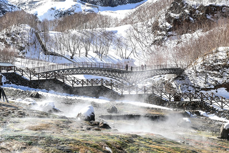
Fig. 1 People visit snow-covered Changbai Mountain in Northeast China's Jilin province, March 7, 2021. [Photo/Xinhua]
Renowned for its quaternary volcanic landforms, the park boasts a wealth of geological remnants including giant compound volcanic cones, millennium-old eruptions and their deposits, debris canyons, and giant crater lakes such as Tianchi. With over 380 craters, it holds the distinction of being the region with the biggest number, greatest density and widest distribution of volcanic rocks in East Asia.
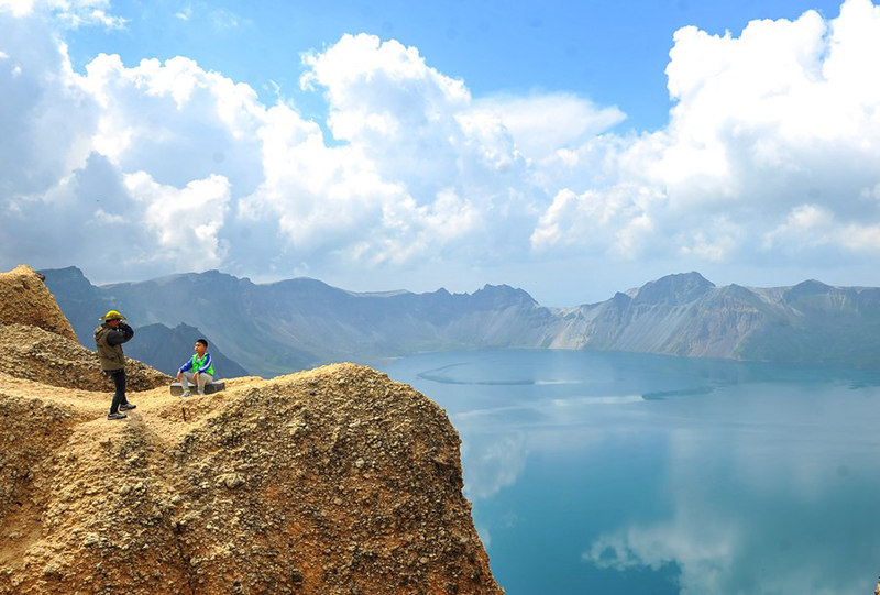
Fig. 2 A child poses for photos at the Tianchi lake on the Changbaishan Mountain in Northeast China's Jilin province on Aug 17, 2015. [Photo/Xinhua]
In 2023 alone, the Mount Changbaishan scenic area received some 2.75 million tourists, a record high, according to local authorities.
"Volcanoes are mysterious natural phenomena and a fascination for young students," said Pan Bo, a researcher from the Institute of Geology of the China Earthquake Administration.
Serving as an important ecological barrier in Northeast China, Changbai Mountain Nature Reserve was established in 1960. In 2009, it was approved by the then ministry of land and resources as the fifth batch of national geoparks. There are 1,586 species of wild animals and 2,639 species of wild plants, including 50 nationally protected wild animal species and 11 protected wild plant species.
In 2020, the park started applying for membership in UNESCO Global Geoparks. A team was set up to carry out field surveys of geological resources, construction of the database and preparation of the application materials.
"With a total investment of over 33 million yuan ($4.5 million), the committee made full efforts in key tasks of infrastructure construction, enhancement of management capabilities and preparation of planning materials," said Zhao Yueming, director of the park's external cooperation department. The upgrade is a testament to the park's focus on educational tourism.
Moreover, the park launched promotional activities focused on geological science among local schools, drawing the participation of over 710 students and further solidifying its commitment to educational outreach.
They upgraded the Changbaishan Museum of Natural History, adding geological-themed elements, ore specimens and folk exhibits to highlight the unique geological and cultural characteristics.
The five other Chinese geoparks newly added this time are Enshi Grand Canyon-Tenglongdong Cave Geopark in Hubei Province, Linxia Geopark in Gansu Province, Longyan Geopark in Fujian Province, Wugongshan Geopark in Jiangxi Province and Xingyi Geopark in Guizhou Province.
Enshi Grand Canyon-Tenglong Cave Geopark is a large-scale geopark with geological site?landscape as the main body and karst landforms and tectonic landforms?as the core. The?Geopark is located at the middle of Yangtze paraplatform,?at the junction of the upper and the middle Yangtze?plate, belonging to part of the northern edge of Sichuan-Hubei-Hunan-Guizhou fold belt. The Geopark has kept?complete sedimentary records of marine and terrestrial facies since the early Cambrian period, and is one of the representative areas of subtropical karst landform?in southern China. At present, the Geopark has 79 important geological sites, including 3 world-class, 15 in national level, 59 in provincial level and 2 below provincial level.
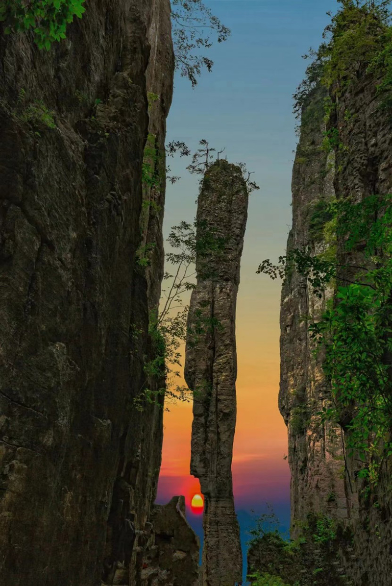
Fig 3. The Scenic Spot Yizhuxiang in Enshi Grand Canyon [Photo/dzgy.enshi.cn]
Linxia Geopark is located in Linxia Hui Autonomous Prefecture, Gansu Province. It spans arid area of the Loess plateau and alpine, cloudy and humid area of the Qinghai-Tibet plateau and covers an area of about 2,120 square kilometers. 6 counties(city) are involved in the Geopark including Yongjing county, Dongxiang county, Linxia county, Guanghe county and Linxia ?city. Linxia Geopark is represented by the Cretaceous dinosaur footprint and the late Cenozoic mammalian faunas and supplemented by the late Cenozoic strata, Danxia Landform in northern Linxia and the Yellow River Three Gorges, integrated distinctive local culture.Linxia Geopark combined geology, ecology and culture and is a comprehensive geopark without walls.

Fig 4. The beauty of Linxia Geopark in Linxia Hui autonomous prefecture, Gansu province. [Photo/gogansu.com]
Longyan UNESCO Global Geopark offers a geological record of tectonic evolution in southeast China covering a period of approximately 300 million years. The geopark’s abundant geological heritage includes the Meihuashan granitic complex, the Guanzhaishan red bed sedimentary rocks and the Zijinshan super-large porphyry-epithermal copper-gold deposit. Home to the densest natural forests of West Fujian, the geopark displays rich biodiversity. The forest coverage of Meihuashan Mountain reaches 95.4%. Longyan is the birthplace of the Hakka culture. Many unique traditions endure to the present day. The Peitian Landscape Roundhouses display the architectural style of the Hakka culture, arranged compactly along long cobbled streets.
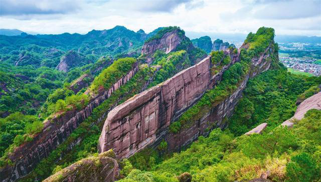
Fig 5. Picture of the geological heritage of Longyan Global Geopark [Photo/fj.xinhuanet.com]
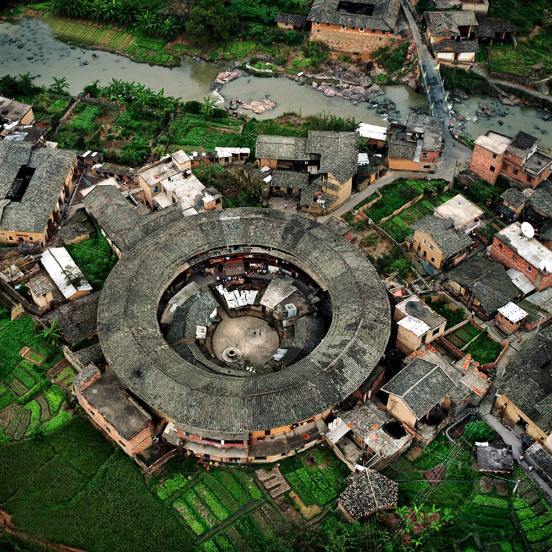
Fig 6. An aerial photo taken in October of 2002 shows the earth houses of Hakka people in Longyan of East China's Fujian province. [Photo/Xinhua]
The Wugongshan Geopark is located in the western part of Jiangxi Province in central and eastern China. The total area of the Geopark is 1470.82km?. According to the distribution characteristics of geoheritages and natural and cultural landscapes, Wugongshan is located in the northern section of the Luoxiao Mountains on the border of Hunan and Jiangxi, and on the south side of the convergence zone of the Yangtze Plate and the Cathysia Plate.
It is the only geopark in the world that takes the granite dome structure as the main body and presents the overall geological and landform landscape. The Geopark has an excellent ecological environment, with a forest coverage rate of 88.1%. The Geopark has a long history and profound cultural accumulation. It is a natural museum left by nature to human beings to study granite domes and their geological landforms, and it is also an important base for people to understand the inheritance and development of Chinese culture.
Xingyi Geopark is a comprehensive geopark with best - preserved and most unique Triassic geological heritages, covering a total area of 1456 square kilometers.
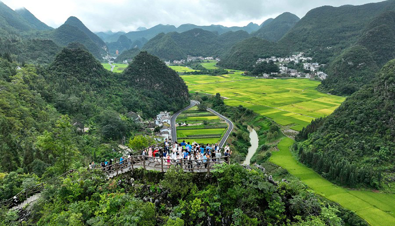
Fig. 7 This aerial photo taken on Aug 25, 2023 shows visitors at Wanfenglin geological park in Xingyi city of Qianxinan Buyi and Miao autonomous prefecture [Photo/Xinhua]
Xingyi Geopark lies on the edge of the Nanpanjiang tectonic basin and the Yangtze platform. It features various international significant geosites. Moreover, the geopark contains a variety of stratigrafic sections, tectonic profiles, landforms in the form of poljes , karst caves, tiankeng, doline, pictographic rocks as well as waterfalls, underground rivers, karst springs and wetlands. The Xingyi geopark has been blessed with some of the best karst landforms in the whole of the Yunnan - Guizhou Plateau.
Source:
1.The State Council the People’s Republic of China website <https://english.www.gov.cn/news/202403/28/content_WS6604d33cc6d0868f4e8e58d9.html>
2.(2020) Global Geoparks in China. In: Chen, A., Ng, Y., Zhang, E., Tian, M. (eds) Dictionary of Geotourism. Springer, Singapore. <https://doi.org/10.1007/978-981-13-2538-0_933>
3.National Forestry and Grassland Administration website <https://www.forestry.gov.cn/lyj/1/lcdt/20240328/553800.html>
4.Chinadaily website <https://www.chinadaily.com.cn/a/202403/30/WS660751aea31082fc043bf85c.html>
5.Offical Website of Enshi Grand Canyon-Tenglongdong Cave Geopark <dzgy.enshi.cn/english/More/Introduction/202303/t20230310_1413022.shtml>
6.Office of the Foreign Affairs Commission of Fujian Government Website <wb.fujian.gov.cn/English/momentsinfujian/202403/t20240328_6421016.htm>
7.Global Geopark Network Website
<www.globalgeopark.org.cn/parkintroduction/geoparks/china/14511.htm>
Edited by Lianying Bao