


On 28th May, 2021, Shanghai Municipal People's Government published Shanghai Ecological Space Sector Plan for 2021-2035 (ESSP) as a sectoral plan of the overall urban plan for Shanghai (Shanghai 2035).
01 Background
To promoting ecological progress, Shanghai 2035 aims to develop Shanghai as a resilient city and an eco-friendly city. The layout of ecological space and the quality of the urban environment are important factors that influencing Shanghai’s urban competitiveness. Therefore, as a part of Shanghai 2035, the ESSP was introduced to establish the ecological space system in Shanghai.
02 The Difficulties of Ecological Space Management
When making the ESSP, planners first identified the difficulties of ecological space management in Shanghai as following:
1) The shortage of ecological space. As a high-densified megacity, the land in Shanghai has already been highly developed. It is difficult to provide more space for ecological uses.
2) The lack of a management system. Currently, the ecological space in Shanghai distributes separated and fragmented. To process the management of ecological space, a comprehensive management system including the spatial layout of ecological space, the protection restrictions and policies should be established.
3) Hardly meet the citizens’ requirements. The quality and function of ecological space haven’t achieved people’s expectations. In some urban districts, ecological space is distributed unevenly and with low quality. The environmental resources in the suburban areas haven’t been fully realized and utilized.
4) Difficult to control developments in ecological space. Parts of ecological space were occupied by urban constructions. The development control in ecological space should cooperate with multiple government institutions, and be supported by systematic instruments.
03 The Contents of ESSP
Planning Target
The ESSP aims to build Shanghai into a socialist modern international metropolis with global influence by improving the ecological space in Shanghai. This plan makes three planning targets, "make the city located in gardens, make the city surrounded by forest corridors, and make blue and green networks in the city".
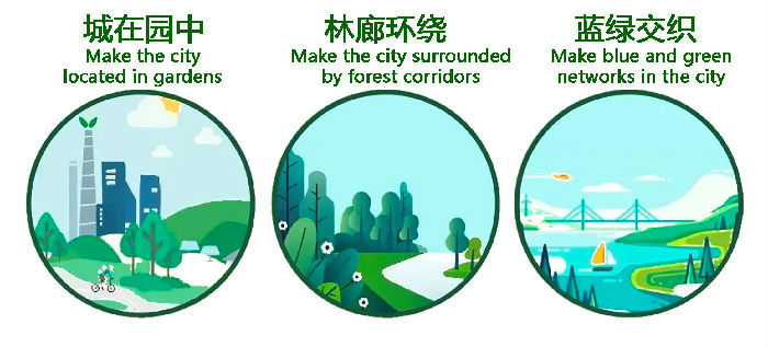
▲The three planning targets
Development concept
There are three basic concepts to develop the ecological space of Shanghai: make Shanghai a city for people, a garden city and a resilient city. To keep the ecosystem healthy and sustainable, mountains, rivers, forests as well as farmlands, lakes, grasslands and deserts all should be considered as indivisible parts of the ecological space. The ESSP is made based on these concepts and also considering the characteristics of a high-densified metropolis.
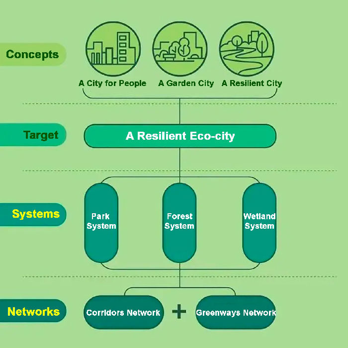
▲A framework of the development concepts, target and the contents of ESSP
Strategic metrics of ecological space
The ESSP introduces several key strategic metrics to track and manage the protection of ecological space.
The area of ecological land (including green space and squares) will be more than 60% of the total land of Shanghai.
The percentage of forest cover will reach 23%.
The per capita public park space will be more than 13 sq. meters and the per capita public park space in urban area of Shanghai will be more than 7.6 sq. meters.
The urban area in Urban Growth Boundary will be covered by the 500 meters service radius of large parks.
There will be more than 30 country parks and 2000 km greenways.
The area of waterbody will be 10.5% of the total land of Shanghai.
More than 50% of wetland will be protected.
Spatial patterns of ecological space
At the regional scale, an ecological pattern will be formed that takes the Yangtze Estuary, East China Sea, Taihu Lake and Dian Mountain Lake, Hangzhou Bay as regional ecological hubs and Yangtze River, Wusong River, Huangpu River as regional ecological corridors.
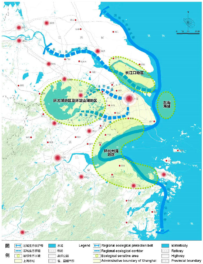
▲ The map of the regional spatial pattern of ecological space in Shanghai and surrounding areas
In the administrative boundary of Shanghai, the ESSP proposes an ecological network that formed by two greenbelts, nine corridors and ten ecological protection zones. The two greenbelts aim to separate urban clusters and control sprawling urban expansion. The nine corridors are the structure of urban ecosystem by providing wind power to the city center and providing animal migration paths. The ten zones protect the ecological and environmental background of the city.
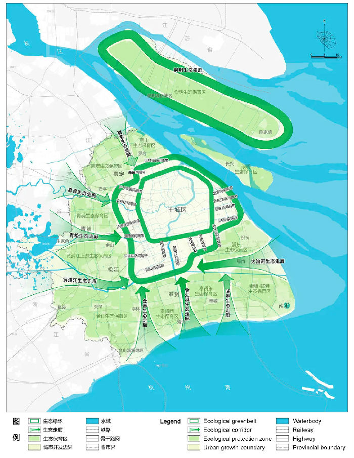
▲The map of the ecological network in Shanghai
In the urban area of Shanghai, the ESSP proposes to optimize the pattern of blue-green space and promotes a connected ecological pattern with Huangpu River, Suzhou River and a circular greenbelt.
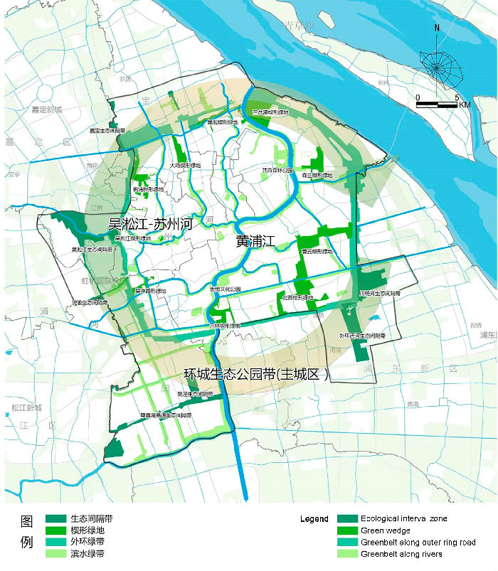
▲The map of blue-green space in the urban area of Shanghai
04 New attempts in making ESSP
Establish an integrated plan for all ecological factors in the planned area.
The ESSP includes one master plan for ecological space and seven specific plans for parks, forests, ecological corridors, greenways, wetland, habitat for wild animals, as well as old and valuable trees. The master plan focuses on establishing the ecological patterns at different scales and introducing the strategic metrics and requirements for ecosystem protection. The seven specific plans provide detailed guidance on the constructions related to ecosystem protection. Following the implementation framework of Shanghai 2035, ESSP integrated the relevant contents in the socio-economic development plan, spatial plan, sector plan and action plan. The implementation section of ESSP includes a planning code, zonal guidance and a short-term action guideline.
Support plan-making with field study and data analysis
During the plan-making process, planners investigated all ecological areas and factors in Shanghai, including 90,000 hectares of forest, 7 country parks, 165 urban parks, 30 town parks, 226 rivers, more than 1,000 parkways, 2605 old and valuable trees. The field study covered all of the 12,886 green space patches in the administrative area of Shanghai. The plan-making team built a database of ecological factors of Shanghai and use multiple methods to analyze the ecological service value, ecological sensitiveness, and wind corridors. These data analyses supported the plan-making and policy decisions of ESSP.
Build an ecological protection framework using restrictive and flexible strategies
The ESSP delineates the different protection zones based on the ecological pattern and applies restrictive and flexible strategies to different zones. The restrictive strategies apply to the areas inside ecological protection redlines. The flexible strategies apply to development-restricted zones. Based on these strategies, the ESSP provides a list of allowed projects and actions in the different zones, to protect ecological space and promote sustainable urban development.
Promote planning implementation and administration
The ESSP provides detailed development targets and strategic metrics of ecological space, according to the territory spatial planning system of Shanghai. The master plan for ecological space is the top-level design at the overall planning level, introducing the development targets, strategic metrics and ecological patterns.
Passing by zonal planning and detailed planning, the seven specific plans are formulated at the detailed planning level. The ESSP makes about 160 urban planning codes, identifying the planning control boundaries and the allowed project and action lists.
Source: <https://mp.weixin.qq.com/s/VU8D3AiT-Q3DVus0H4z_Fw>
<https://mp.weixin.qq.com/s/dnzPXUKZXEqyRv0uPFbrKQ>
Edited and translated by Jia Mengyuan