

In October 2016, the UN-Habitat Ⅲ Conference introduced "Resilient Cities" as a new component of the New Urban Agenda. To promote the resilience of cities in China, the Beijing Municipal Institute of city Planning & Design together with Tsinghua University, IGSNRR of CAS, and ATLAS company completed a project on the resilience planning strategy of Beijing. This project has been rewarded as one of the 2019 Excellent Urban Planning and Design by China Association of City Planning.
Based on the social and environmental context of Beijing, this project established a list of hazard factors for Beijing, and optimized the risk assessment model. They formulated an urban resilience criteria, including the evaluations on urban system and on resilience management. Strategies on improving urban resilience were proposed to promote a sustainable and livable Beijing in the future.
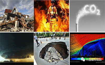
1. Understanding the hazard factors of Beijing
Based on a list of hazard factors introduced by the Public Safety Research Center of Tsinghua University, this project selected 37 factors as study objects considering the frequency of hazards, the intensity of disaster, the impacting areas and its relevance to urban planning. There are 16 kinds of natural hazard factors, such as flood and drought disasters, meteorological disasters, earthquake disasters, geological disasters, biological disasters and bush fires. There are 13 kinds of accidental hazard factors, such as mineral accidents, traffic accidents, public facilities accidents, dangerous chemical accidents, fires, environmental pollution and ecological destructions. Also, public health (3 types) and social security (5 types) are considered in the list, including infectious diseases, chronic outbreaks, food and drug safety, terrorist attacks, demonstrations, ethnic and religious conflicts, drug control and public security.
2. Optimizing the risk assessment model
2.1 The risk assessment model for single hazard
For the 16 kinds of natural hazard factors, this study established a risk assessment system to evaluate the risk of disaster-causing factors, vulnerability of disaster-bearing factors, the ability of disaster prevention and its influence on secondary disasters. Using this risk assessment system, this project evaluated the typical natural hazards in Beijing, including debris flow, bush fire and snowstorm disaster, and identified the risk level, impacting area and potential economic loss of each hazard.
For the 13 kinds of accidental hazards, a single disaster risk assessment system of major hazard sources was established. Using the dynamic evolution model and studies on multiphase coupling effects, this project quantitatively evaluated and predicted the combustion and heat transfer process, the spread range and the possible damage to people and buildings, if an explosion happens. This study also coupled the population and economic factors in modeling the risk of explosions and dangerous chemical leakage. This model can support studies on making risk management strategies.

Figure 1 Evaluation of different hazards
2.2 Coupling multiple hazard risks
Based on the assessments on single hazards, this project established a comprehensive risk evaluation system. The chain theory and event chain theory were employed to identify the inner-correlations across the typical hazards. This study built a matrix to identify the coupling relationship of different risks. The dynamic risk assessment model of urban disaster chains was established by combining spatiotemporal data mining method with disaster dynamic evolution method.

Figure 2 A evaluation model of the risk chain: Typhoon-Strom-Landslide-Urban Ponding-Traffic Congestion (UPSC)
3. Draw a map of risks in Beijing
In order to make a risk map of the whole administrative area of Beijing, this study overlaid the 54 layers of risk data into one map. In this risk map, there are 8,291 vector patches of risk zones. By selecting the high-risk patches and encoding them, a database of Beijing risks was established. Local governments, urban planners and citizens can check the information of potential hazards and its risks of selected area by this database.

Figure 3 A zoning map of hazard risks in Beijing
4. Evaluation of urban resilience
This study evaluated the resilience of Beijing from two dimensions: Urban system and resilience management. A criterion including 12 aspects and 83 indices are established to evaluate the extent of urban resilience. Using these criteria, researchers studied the resilience of Beijing in 2017 and predicted the resilience after the new master plan implemented. The result shows that the urban system of Beijing has advantages in social environment and urban infrastructure, but has weakness in ecological environment. For the resilience management in Beijing, the result shows that the administrative ability is high, but the recovery ability and the cooperation across Beijing-Tianjin-Hebei region still need to be improved. The score of urban resilience is 2.60 in 2017, and is predicted to be 4.48 in 2035.

Figure 4 the framework of urban resilience criterion(UPSC)
5. Strategies on improving urban resilience
The project provided several strategies on improving urban resilience of Beijing in the future.
Control urban growth: the central city is the most vulnerable area for the risks. The city should strongly control the growth of population and building density in the central area.
Optimize land-use layout: for the high-risk zones identified in this study, local governments should control the type of developments in these areas. For dangerous risk factors, if they cannot meet the requirements of the safety, local governments should monitor and relocate these risk factors as soon as possible. We should pay more attention to the elderly and children in the outer suburbs, by establishing a list of vulnerable groups and educating them the awareness and ability of self-rescue for disasters.
Improving infrastructures: we should improve the stability of urban infrastructures, such as design for a higher standard to react to the extreme weather and make a network connection between the infrastructures so as to support the safety and stability of the main lines.
Improving disaster prevention and response capability: strengthen the plans for emergency shelters, disaster avoidance channels and disaster relief channels.
Establishment of risk management system: all the local governments, social groups, and communities are encouraged to build strength connections, and form a multi-level integrated management system.
Authors:Dan Zhao, Yong He, Bing Yang
Translated by Jia Mengyuan
Copyright @ 2014 Urban Planning Society of China
Registration Number:05073892-1
