

China Urban Planning Academic Season is an online academic brand organized by the Urban Planning Society of China from September 16 to 26, 2020. In 2020, the academic season has triggered a boom in online academic exchanges in China through 86 online academic activities.
Introduction
On September 21, 2020, the " Accompany · Growth" theme activity in China Urban Planning Academic Season of UPSC, sponsored by CAUPD (China Academy of Urban Planning & Design), was successfully held. This is a report delivered by Zhu Ziyu, Chief Planner of CAUPD.
Report Compilation: Zhang Yuan;
Proofread: Chen Zhenyu

Zhu Ziyu, Chief Planner of CAUPD
1. Significance and Basic Requirements of the Establishment of the Xiong'an New Area
According to the forecast, the Xiongan New Area should be built into 1) a new green, ecological and livable urban area, 2) a demonstration area for coordinated development, 3) a leading area for innovation-driven development, and 4) a pilot area for open development. In order to achieve these goals, the CPC Central Committee clearly pointed out that planners need “world vision, international standards, Chinese characteristics and high positioning”。
(1)International standards: To achieve the international leading level, it is critical to gather the advanced concepts, standards and practical experience of various countries and regions in different fields.
(2)Chinese characteristics: To tell China's story, the core is to promote Chinese wisdom, propose Chinese solutions, pool China's strength to solve the world's dilemma.
(3)High positioning: To set a benchmark of the new era, it is significant to establish a pattern of ecological civilization as well as high-quality development.
2. Planning Practice of Xiong'an New Area under the New Development Concept
(1) Ecological Priority
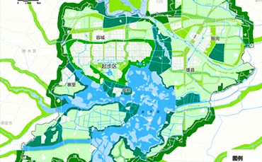
The core of ecological priority I to construct a “full-level ecological security pattern”。 And the establishment of the Xiong’an New Area is a crucial step in the coordinated development of the Beijing-Tianjin-Hebei region. Furthermore, the protection of Baiyangdian Lake, which is known as "kidney of North China", is also a significant task that Xiong'an New Area plans to carry out resolutely. The plan aims to immerse the city in nature. As a result, a key strategy is to construct the ecological security pattern, namely "one lake, three belts, nine districts and multiple corridors".
"One lake" refers to environmental management and ecological restoration of Baiyandiang Lake; "three belts" refers to the construction of three green belts around Baiyangdian Lake, start-up area and New Area respectively; "nine districts" means to establish nine large forest patches to enhance carbon sequestration capacity and biodiversity protection; "multiple corridors" means to the construction of multiple green ecological corridors, playing the role of protecting water, increasing vegetation, ventilation, dust removal and so on.

Figure 1. territorial spatial layout with ecological priority
At the index level, first of all, it is necessary to ensure that the overall proportion of “blue and green” space in the New Area reaches 70%. Considering the standard of forest city in the future, we hope that it could be stable at 70%, which requires that the urban and rural buildable land of the New Area should be strictly controlled at 30%. Under the requirement of ecological priority, the ecological spatial control units are demarcated for all non-buildable land with detailed control indexes. In this system, dominant ecological functions, habitat types, vegetation, water bodies, recreational facilities, and biological habitat characteristics are all incorporated into the ecological unit structure for control.
(2) Green Development
·Spatial Pattern Conforming to Nature
It is quite challenging to adapt the planning to the natural conditions of the site. This requires planners to prioritize the use of higher terrain areas to centralize the layout of urban construction areas. Meanwhile, it also demands the use of appropriate engineering means to deal with the terrain, in order to retain sufficient depressions for rainwater storage, so as to build a multi-functional ecological wetland system.
The site of the New Area is located on the edge of Baiyangdian Lake. Hence, the lake is critical in the planning scheme. In the early stage of the planning, we reached several consensuses, including: 1) the land of Baiyangdian Lake can’t be occupied; 2) the construction near Baiyangdian Lake should be considered carefully; 3) the layout of urban area should be decentralized and flexible, so as to realize the integration of city and lake. Afterwards, the planning basically follows these ideas.
The ecological spatial pattern, conforming to natural condition, brings effective ventilation corridor to the city. Furthermore, it also provides efficient water space for urban drainage and waterlogging prevention. As shown in the figure below, on the left is the drainage organization of the start-up area, while the right figure indicates the range of water logging once-in-50-years in this area. On the basis of the existing highlands, the planning takes “group” as the basic unit, forming the ecological spatial mode namely "turtle back type" and "leaf vein type". On this basis, a drainage and waterlogging prevention system with "ecological regulation and storage" as the main body is put forward.

Figure 2. the ecological spatial pattern
·Green Transportation System with Comprehensive Policy
As for transportation system, according to the plan for the Xiong’an New Area, green transportation in the starting area should reach 90%. In terms of composition, the traffic structure of the start-up area is: 20% for rail transit, 25% for public transportation and 50% for slow traffic. The details are as follows:
First, scientific density of road network. The road network density of the start-up area should reach 10-15 kilometers per square kilometer (including slow road), and the width of the road should be designed reasonably. The road network density of the industrial park is 8.5, that of the community is 9.0, while that of the commercial block is above 10. In a nutshell, there is no unified road density index in regulatory detailed planning, and the density of road network is determined according to land use.
Second, the ground bus system. The three-level public transport network of "expressway, trunk road and branch road" is established and operated intelligently. The network density of bus lanes reaches 3 km/km? and has been implemented in the trunk road system. In addition, the bus branch line launched in the community should improve the service level through intelligent service to meet the actual demand.
Third, the greenway system. To fully prepare for slow traffic, it is necessary to set up regional greenways, community greenways and urban greenways. Only in this way can citizens be encouraged to reduce the use of cars, so as to implement the concept of " Let the regional greenway enter the city, and the urban greenway enter the community ".
Fourth, the parking system. In order to change the habit of providing parking facilities blindly and treat parking facilities differently. It is critical to ensure supporting facilities in residential areas while set an upper limit of commercial buildings. Meanwhile, the planning should guarantee parking facilities of large public buildings such as hospitals.
·Mixed and Shared Urban Space
First, intensive land use. In the start-up area, all kinds of land should be reasonably distributed. Meanwhile, the construction scale and population density should be determined scientifically, so as to form an urban development pattern with moderate scale, orderly space and efficient land use. The site area of the start-up area should be controlled at about 100 square kilometers, while the building density above ground shall be about 100 million square meters.
Second, comprehensive land use. The leading function of land use should be clarified, and the flexible control of land use function should be implemented. Meanwhile, planners should comprehensively layout the land use function and respond to the demand of urban development with flexibility. In addition, mixed-use of land should be carried out in order to enhance urban vitality.
Thirdly, the compound use of space and the superposition of business. The recombination of building functions in horizontal and vertical spaces should be encouraged to make full use of the differences in privacy and landscape caused by different floors and positions, so as to maximize the spatial value.
Fourth, integrative design. Through different design methods, the urban space with diverse organization, abundant functions and blended landscape is formed.
(3) Cultural Inheritance
·The Idea of Constructing a City
The square shape is the prototype of "ideal city" in China for thousands of years, especially in north China. And axis is a classical way for traditional Chinese cities to establish spatial order. Meanwhile, China's unique overall planning concept of “urban - suburban - field” is a significant form of construction. Nowadays in Xiong’an, the start-up area, retaining the gene of Chinese culture, forms the urban space as "one square city, two axes, five groups, ten gardens, hundred fields, millennial forest and one lake".
“One square city” refers to the form of square city, which organically combines the traditional humanized scale theory with the modern pattern of “small block, dense road”, so as to determine the pleasant scale of land and neighborhood.
“Two axes” refer to the two axes of the city. The north-south axis, which shows the historical and cultural ecological characteristics, highlights the symmetry of the central axis. While the east-west axis is a “green necklace” connecting the key nodes of the start-up area, which is also the main corridor of urban rail transit. “Five groups” are five urban clusters with comprehensive functions, proper density and suitable scale in the layout of "North City".

Figure 3. the pattern of the start-up area
“Ten gardens” and “hundred fields” constitute the ecological landscape structure of "one core, two belts; two pieces, four dots". Furthermore, “millennial forest” and “one lake” are fully utilized to construct the regional green ecological spine, suturing the landscape of the start-up area and Rongcheng County.
·Cityscape
In order to reflect the style and characteristics of the city, there are several measures in the planning of start-up area.
First, the whole shape is smooth. The overall height of the city is uncurving, while there are scattered parts. The building height in general areas is controlled below 45 meters.
Second, the overall shape has rhythmic fluctuations. Highlighting the structure of the city center and the shaping of the skyline, the heights of buildings are controlled in different areas. The high-rise buildings are properly arranged in the surrounding areas of intercity stations, financial islands, and cluster centers, forming an urban skyline with an unstretched and well-arranged outline.
The third is the classification of density and control. The average construction density of the start-up area is about 10,000 m2 / ha. On this basis, the development density of different districts should be balanced as a whole and controlled at different levels, so as to form an urban pattern with compact and efficient production, comfortable and friendly life, open and pleasant ecology. Meanwhile, the development intensity of different functions should be determined by comprehensively considering the location, industry, transportation and resource conditions.
·Cultural heritage and nostalgic memory
Space is the superposition of multiple space-time information. In the early stage of planning, planners carried out a comprehensive survey of cultural relics in order to protect historical sites, ancient buildings, nostalgic elements etc., and combining them with the design of open space system for reasonable display and utilization.
According to the characteristics of each village’s current situation, the planners identify the monuments, temples, ancient wells, ancient trees, ancient houses etc. that can retain the historical marks. On this basis, the land use could be divided into three categories: protection in original site, reconstruction in other places and transformation into park, which lays a foundation for the future design.

Figure 4. the map of historical marks
Conclusion
The planning of Xiong'an New Area endeavors to practice the New Development Principles and explore the national model of high-quality development in order to depict the spatial paradigm of ideal urban construction.
The original text of the report is in Chinese. According to the contents of the report, it is sorted out and posted on the official website of UPSC. All figures are from the original text. Some of the contents have been adjusted in translation.
Copyright @ 2014 Urban Planning Society of China
Registration Number:05073892-1
