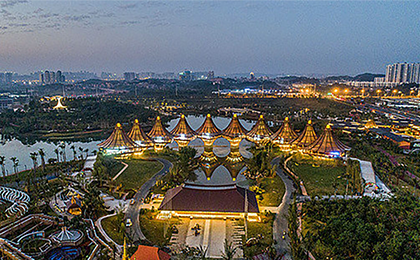


▲ Within the Nanning Garden Expo Park lies the China-ASEAN Friendship Pavilion, a symbolic structure that links 10 pavilions representing the bond between China and 10 ASEAN nations. [VCG]
5. Planning Contents.
5.3 Upgrading green city to build an ecologically livable capital city for Guangxi Zhuang Autonomous Region.
(3) Creating an open space system of “One Belt, Two Cores, One Ring, and Multiple Corridors”.
Integrate the citywide ecological network with the open spaces in the central urban area, achieving a harmonious blend of blue (water) and green (natural areas) spaces, fostering city-nature integration, preserving the “nature in the city”, and shaping the “city in nature”.
“One Belt” refers to the green belt along the Yongjiang River.
“Two Cores” refers to Qingxiu Mountain Scenic Area and Wuxiangling Autonomous Region Forest Park.
“One Ring” refers to the suburban recreational ring connecting parks and urban-rural agricultural landscapes around the central city.
“Multiple Corridors” refers to the green corridors formed along rivers such as Ximing River, Keli River, Xinwei River, Chaoyang River, Shajiang River, Liangfeng River, Zhupai River, Naping River, Machao River, Bachi River, Lengtang River, etc., linking the Yongjiang River with the suburban recreational ring.
(4) Improving the park and green space system.
Develop urban and suburban greenways to connect parks and natural areas. By 2035, the per capita green park area in the central urban area will reach 12 square meters, and the coverage rate of parks and green spaces within a five-minute walk of more than 400 square meters will be at least 90%.
(5) Improving the public service center system and coordinating the layout of public service facilities.
Establish a three-tier system for public service facilities in the central urban area, namely, “city-level, district-level, and community-level”. Optimize the spatial layout of healthcare, elderly care, education, cultural, and sports facilities. By 2035, the 15-minute walking coverage rate for all types of community public service facilities will be significantly increased.
Configure public service facilities in cities and counties according to urban standards. In townships and rural areas, define 23 township life circles within a 30-minute driving radius to achieve comprehensive basic public service coverage.
(6) Optimizing urban rail transit and road networks.
Develop a “six-horizontal, six-vertical” high-speed transit network and an “eight-horizontal, six-vertical” structural road framework to achieve open and interconnected urban traffic. Build a multi-level, high-quality public transportation system with large and medium capacity rail transit as the backbone, conventional buses as the foundation, and specialized transportation as the supplement, to promote green and sustainable modes of transportation.
(7) Promoting revitalization of existing urban spaces by zoning and categorization.
Adopt a zone-based and category-based approach to revitalizing existing urban spaces, guided by objectives such as optimizing spatial layouts and functional structures, improving public services and infrastructure, and enhancing environmental quality and governance capabilities, so as to support urban renewal initiatives that emphasize intensive, compact, and green development, fostering high-quality urban growth.
5.4Establishing comprehensive systems for lifelong spatial management.
(1) Establishing a comprehensive territorial spatial planning system.
Establish a “three-tier and three-category” territorial spatial planning system with full regional coverage, layered management, and categorized guidance.
(2) Building a “one map” for territorial planning with integrated thinking and multiple capabilities.
Integrated data support: establish four major categories with 26 databases encompassing current conditions, management, planning, and socio-economic data. This ensures a precise understanding of the city’s geographic, natural resource, and departmental planning data to scientifically assist in spatial layouts and planning processes.
Inter-connected systems: integrate multiple operational systems to transition from fragmented management to an organically unified framework. This guarantees the comprehensive coordination and effective implementation of planning content.
Multi-scenario visualization: leverage foundational data and algorithmic models to build scenarios for inventory management, baseline control, and indicator monitoring. This enables interactive visualization through high-quality thematic data displays on large screens.
(3) Establishing and improving a dynamic monitoring, assessment, and early-warning mechanism of territorial planning.
Under the requirements of regular checkups and five-year assessment, and in conjunction with the results of annual land use change surveys and geographic condition monitoring, a sound early-warning mechanism for monitoring and assessing the implementation of territorial planning should be established, and reviews and assessments should be conducted regularly. Adjust and refine the plan dynamically based on results from national economic and social development plans and implementation assessment of territorial planning.
Source:<https://mp.weixin.qq.com/s/pIvve09Ct3OLzU2iJOcjDQ>
Editor & Translator: GUO Xinxin
Copyright @ 2014 Urban Planning Society of China
Registration Number:05073892-1
