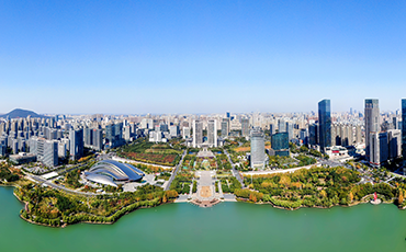


The State Council has approved a national territorial spatial plan for Hefei city, the capital city of East China’s Anhui province, for the 2021-2035 period, according to an official reply issued on Dec 12.
As per the reply, by 2035, the total area of cultivated land in Hefei should be no less than 7.0517 million mu, of which the protection area for permanent basic farmland should be no less than 6.1852 million mu, the red line area for ecological protection should be no less than 1,228.40 square kilometers, and the boundary area for urban development should be within the limit of 1,289.30 square kilometers.
To support the new development pattern, the reply called upon Hefei to play an active role in serving the joint construction of the Belt and Road Initiative, and participate in the development of the Yangtze River Economic Belt with deep integration in the development of the Yangtze River Delta.
Meanwhile, regional coordination for land use and space development and protection in the Hefei metropolitan area should also be strengthened, according to the reply.
The development and protection of territorial space will be systematically optimized, the reply added.
To that end, efforts will be made to accelerate the construction of an urban system with regional coordination and urban-rural integration, and coordinate ecological protection and restoration in the Yangtze River and Huai River basins.
While ensuring the space demand of modern urban agriculture, priority will also be given to the development of scientific and technological innovation and advanced manufacturing.
In addition, the city will work toward becoming an international aviation hub and a national railway hub with a safe, convenient, green and low-carbon comprehensive urban transport network.
A spatial system for the overall protection of cultural resources, natural resources and landscape resources should also be built, according to the reply.