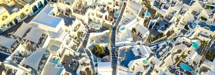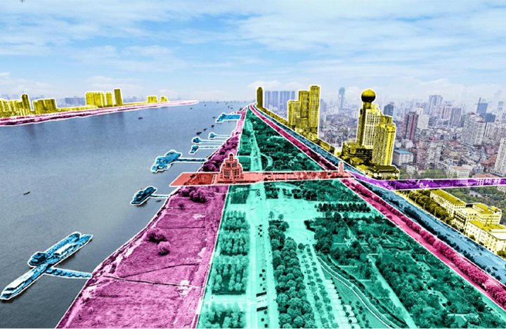


3.2 Strategies learning from the “Big U” Planning and Wuhan Waterfront Park cases
In order to meet the high-standard requirements of development, the waterfront regeneration design strives to reshape the relationship among people, water, and the city. On the basis of traditional waterfront redevelopment and old city regeneration processes, it returns to the initial movement among water, people, and cities, realizing the high integration of waterfront ecological, cultural, and living space, and creating a brand-new multi-functional area of new urban area integrating leisure, culture, tourism, commerce and live.
The first is adding targets towards the certain area. By connecting the surrounding development, define the function of the area, create a unique first-line riverside area that lights up the main axis, and create a new landmark that focuses on the multiple goals of industrial upgrading, landscape improvement, economic prosperous with rich culture alongside the Yangtze River.
The second is functional agglomeration. By adjusting the alignment of Linjiang Avenue and the innovative landscape utilization of riverbanks, the ecological space will be maximized, and multiple resources such as urban resources, cultural resources, riverside resources and traffic resources to achieve the aggregation of municipal infrastructure and urban service functions.
The third is land use compounding. Through multi-dimensional spatial design, flexible control of land use, create a comprehensive waterfront functional area with intensive land use and diverse types of spaces. By using the limited waterfront area in the central city, it can meet the desire of protecting and utilizing industrial heritage, improving the quality of urban service, and at the same time satisfy the requirements of ecological protection and multifunctional organic combination.
04 Riverside Space Protection and Development Strategy
4.1 Strategy 1: recreating urban landscaping and shoreline stitching.
In order to solve the dilemma of "standing at the riverside but not seeing the river" in Binjiang area and connect the urban area with its waterfront, the first thing is to solve the obstacles in traffic path and increase the architecture setbacks along the river to the maximum the public places, so as to provide the most favorable support for the reconstruction of ecological public space in Binjiang area. First, the overall urban traffic system should be sorted out in traffic organization, and the optimization strategy of road traffic function system should be put forward based on the principle of the Master Plan and adapting to local conditions, fully combining the special situation of the site and urban design scheme. The second is coordinating the traffic connecting the external space and dock areas, to connect the traffic system planning in the waterfront residential area to the overall planning, and organically combine the vehicles and pedestrian in the city in a suitable position, and connect with bus stops, subway stations, and water ferry ports. The third is to break through the space, connect the waterfront, carefully design the activity flow of residents, ensure people’s safety, greatly satisfy the needs of citizens and tourists for public activities, and design a waterfront greenway with continuous characteristics.
4.2 Strategy 2: Integration of embankment and landscape
Riverside area is facing the safety requirements of dike in disaster prevention and flood control, ensuring the constant flood control standard and the stability and safety of dike, exploring the feasibility of ecological flood control measures and landscape flood control dike treatment, and improving the accessibility of landscape public space and the quality of activity experience. By raising the site through three-dimensional treatment, the height difference between the flood control wall and the ground will naturally transition, and the barrier-free connection between the river embankment, parks and urban roads will be achieved, so as to maximize the river view.
4.3 Strategy 3: Organic ecology and interactive symbiosis
Riverside area is not only the space for urban public activities, but also a multidimensional interactive space in linking the "water" with "urban ecology, traffic, urban form, urban function, urban life, and urban culture". In urban design, more attention is paid to the connection and integration between ecological spaces and urban spaces, so as to build a rich landscape and create a comfortable and pleasant space environment.
4.4 Strategy 4: Recall memory and gather in multiple ways
As an important spatial component of Wuhan's strategy of "supporting the development of areas surrounding the river", the riverside area bears multiple goals such as the construction of ecological civilization on the Yangtze River, the transformation of old industrial bases, and the improvement of urban functions. Combining regional economic development orientation and industrial orientation, we will effectively balance protection and utilization, build a brand-new area containing the historical memory of the city and showing the modern spirit. Create a multi-functional area such as ecology, culture, tourism and living, build a new urban landmark with brand-new functions and provide sense of places. First, inherit the urban context, keep historical buildings and cultural elements in the waterfront design, and keep traditional venues to build public open spaces with humanistic values; The second is to preserve and reuse valuable industrial heritage, retain historical memory and texture, and activate and develop old industrial buildings by implanting new functions; The third is to optimize and integrate the public services and tourism and leisure functions around the region, fully tap the potential of tourism supporting businesses, increase the supporting businesses of characteristic culture and entertainment through functional reorganization, and comprehensively improve the quality of riverside spaces; Fourthly, the waterfront residential function should be arranged properly, ecological green buildings should be advocated, the proportion of the public service function in communities should be increased, and a high-quality and opening community with perfect supporting facilities should be created.
4.5 Strategy 5: urban landscape coordination and flexible management
The urban interface on both sides of the Yangtze River is an important window to show the city's image. Through the research on urban design of Binjiang District, this paper puts forward the guidance and construction control of the development and construction of Binjiang City. First, refine the road network in the hinterland of Binjiang, create small-scale spatial texture, set up multiple landscape sight corridors, and create a green and transparent waterfront block with appropriate scale; Second, under the historical texture of the ancient city and the line of sight protection and control of the Huanghe Tower, arrange landmark buildings on proper position, build a good riverside skyline with ups and downs, scattered back and forth and different setbacks; Third, the new building integrated with the historical architecture by similar styles and urban color, highlighting the style and image characteristics of the ancient city; The fourth is to control the land use as mixed land, implement flexible control on land compatibility, accommodate various functions to the maximum extent, to achieve efficient and intensive land use and improve economic vitality.
05 Conclusion
Based on the demands of waterfront construction along the Yangtze River, this paper analyzes the difficulties in the regeneration design of riverside space under the requirements of ecological civilization construction in the new era. In terms of the high-quality development and reasonable protection and redevelopment, the paper puts forward five strategies, integration and composite utilization of riverside ecological and urban spaces. Starting with the two main design-riverside traffic and flood control, this paper analyzes the upper design restrictions on the construction of open space, and puts forward strategies such as integrating flood control and landscape design to maximize the utilization of waterfront landscape, build an open space system with continuous opening and interconnection between places alongside and far away from the river. Considering the coexistence of historical context inheritance and urban development interests, this paper explores the path of industrial transformation and regeneration of the old city, and puts forward strategies such as functional reorganization, landscape coordination and flexible control of land use, so as to achieve the multi-scaled innovation and integration of ecology, culture, landscape, architecture and other fields in the process of urban development and regeneration.
Author: Zhang Zhiqing, Wuhan planning and design Co., Ltd
Source:<https://mp.weixin.qq.com/s/VaY4KLZuiso44d-1z-xhhA>
Translated by Zhang Chenxi