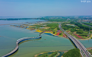

▲ Aerial overview of Yuandang Lake in Qingpu District, Shanghai. [SHQP.gov]
2. Spatial Structure and Planning Strategy.
2.2 Industrial development.
Implant beautiful scenery and cultural elements into the innovative industrial and residential network. As the frontier of new economic innovation of the Yangtze River Delta and the practice place of high-quality development integrating the three dimensions of production, residence, and ecology, it will become the core zone for collaboration and innovation.
2.3 Public services and housing security.
Adhere to a people-centered approach, and establish a diversified housing security system while ensuring equitable and high-quality service facilities. The community life circle plays a fundamental and comprehensive role in improving public services to strengthen people's sense of fulfillment, happiness, and security.
2.4 Transportation system and infrastructure facilities.
Adhere to prioritize public transportation, and comprehensively plan various transportation facilities. It aims to establish an integrated transportation system that connects the “Water Town Lounge” with external trunk roads to enable zero transfer and efficient connection between multiple transportation modes and establish a convenient, safe, green, low-carbon, intelligent, and economical modern transportation system. Green and intelligent principles are emphasized, green and low-carbon lifestyles will be promoted, and infrastructure construction and operation mode will be innovated as well to develop a green and intelligent municipal facilities system.
2.5 Ecological environment and disaster prevention.
Guided by the principle of “ecological priority and green development”, efforts will be made to promote an ecological, green, and low-carbon development model. It takes the lead in exploring the building of a centralized leading zone for substantial implementation of the dual-carbon strategy. Efforts will be made to reduce emissions, increase capacity, and improve quality to jointly establish a harmonious ecological system, a green and innovative development system, a coordinated environment institutional system, an integrated environmental management system, and a modern and resilient security system.
3. Innovation of the Planning.
3.1 Integration of digital platform for seamless data synthesis.
In the daily planning, construction, and management work of the three regions, the local geographic coordinate system is adopted which makes it difficult to integrate all planning data to form a joint basic working map. During the planning preparation process, the China Geodetic Coordinate System 2000 was adopted as the geographic information benchmark for an integrated digital platform to realize simultaneous conversion and seamless synthesis. The executive committee initiated Shanghai, Jiangsu, and Zhejiang to develop a special geodetic coordinate conservation platform to realize seamless data conversation of the demonstration area, meeting the different needs of integrated planning and administrative-territorial management.
3.2 Integration of spaces.
In the planning of “Water Town Lounge”, a new borderless space will be created, which means the administrative boundaries will be neglected and take the geodetic datum of the Yangtze River Delta and its surrounding regions as a whole to build a “one destination, one core, three parks, three zones, three ways, and many villages” spatial structure, and establish an integrated cores-provincial spatial system.
3.3 Integration of relevant elements.
To comprehensively respond to the new development requirements of the national territorial planning system in the new era, fully implement the master plan and urban design of the demonstration area, completely assimilate the innovative practices carried out in rural planning and suburban planning, break through the limitation of the traditional detailed planning focusing on the areas within the urban development boundaries, and build an urban-rural spatial layout with full coverage of all elements to deliver a combined space with ecological and functional integration.
3.4 Integration of project coordination.
In the process of planning, following the requirements of high-level planning, high-standard construction, and high-quality development, the public services and supporting infrastructure across regions will be reasonably arranged, and key projects in the demonstration area will be coordinated with the support of implementation to effectively ensure and enhance the display and demonstration of the “Water Town Lounge” construction.
3.5 Integration of planning expression.
Under the requirements of not changing the administrative relation and neglecting the administrative boundaries, detailed planning is prepared with the formation of “1+3”. “1” refers to one set of integrated detailed plans, which incorporate the experience of the three regions while ensuring fundamental entries are not missing, the major elements are unique, and data indicators are implementable based on national regulations. “3” refers to three sets of technical results translated separately according to the local technical standards, which are managed with the involvement of “one map” to ensure the implementation of planning.
Source:
<https://www.shanghai.gov.cn/nw12344/20230524/369005102fd44ee2ac97c47786ad81ba.html>
<https://mp.weixin.qq.com/s/gmnmTYtHup0dXyYs30M3MQ>
Edited and Translated by Guo Xinxin
Copyright @ 2014 Urban Planning Society of China
Registration Number:05073892-1
