2.3 The leisure demand of residents does not match the quality of public space
In the new era with rapid economic development, citizens' psychological demand for nature and water is increasingly strong, and the requirements for the open riverside spaces, high-quality landscape, and the sense of places are gradually improving. Riverside ecological landscape space lacks multi-dimensional integrated design, and the construction of places for public activity and recreation is not perfect, which cannot meet people's demand for high-quality leisure experience. However, Jiangtan Park, square, street and urban residents' living space are relatively independent, and the walking line is interrupted by residential areas, streets, roads, and embankments. The organic connection between natural water shoreline and urban public space in Binjiang District needs to be strengthened.
2.4 Cultural protection and industrial transformation need to be integrated
The waterfront at the core of the urban areas along Yangtze River has the longest urban history and the richest cultural landscape resources. At the same time, a large number of abandoned factories, shanty towns and old communities are left behind. Due to the large area occupied by abandoned factory units, the aging trend of old communities is obvious with a high population density, and the relocation is difficult. At the same time, urban construction is restricted by a series of control restrictions, such as the protection of the sight of the ancient Huanghe Tower, the protection of historical relics and industrial remains, and the direct zoning of the central city. It is urgent to promote the regeneration of surrounding old cities through a successful industrial transformation and a feasible regeneration and updating a certain area, so as to achieve multiple goals, like stimulating urban economic development, enhancing the attractiveness of the inner city and improving the urban ecological structure.
2.5 The single land use function with an unsatisfied construction interface
The construction of Binjiang District is mainly based on simple residential development or riverside business district development, and the land use function is single, lacking sustainable development and more inclusive comprehensive use development zones, impeding to the implementation of multiple functions of waterfront. At the same time, the planning and control of the skyline and coastline on both sides of the riverside are still being improved, and the construction along the riverside is characterized by diverse functions, different styles and uncoordinated styles. The texture, architectural style, and color of newly-built constructions and those of the buildings in ancient sites need to be coordinated and unified. The features of the ancient city and the waterfront architectures are not prominent, with an invisible landscape of landmark buildings in Binjiang District. The height of constructions forming the urban skyline are the same, which cannot reflect the characteristics of Wuhan metropolis waterfront.
03 Case study
3.1 Experience from other cases
Flood has long been a global topic, and governments from different countries and research institutions around the world have never stopped thinking about flood control. In urban planning, combining flood control with public space to improve the adaptability and diversity of urban waterfront environment has gradually become the focus of discussion among planners.
3.1.1 New York “Big U” Planning by BIG
Planning BIG, a Danish architectural firm, designed a U-shaped protection system for the coast of Manhattan Island, which is called "THE BIG U" ("Big U" Planning). The scope of this planning project starts from 54th Street in Manhattan in the west, ends at 40th Street in the east and ends at Battery Park in the south for 10 miles, providing a dynamic protection zone for low-lying areas. The protection zone is composed of many linked design factors. The design has formulated its own flood control mechanism for each local community according to different time and scale, and provided each relatively independent flexible functional block, which turned the original monotonous and indifferent flood control facilities into the landscape and service facilities integrated into residents' lives. The "Big U" planning is regarded as a revolutionary flexible blueprint, which is actually a flood control infrastructure disguised as a park. As an "invisible flood barrier", it not only resists floods, but also focuses on improving the quality of public spaces and ecological environment of urban waterfront areas, enhancing the community functions and cultural activity atmosphere, further increasing social benefits, and finally forming a high-density, dynamic, and resilient protection system.

Figure 4. "Big U" Planning along Manhattan coastline.
3.1.2 Sasaki Wuhan Yangtze River Waterfront Park
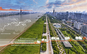
Sasaki Planning & Landscape Office of the United States made a new exploration on the key areas of the Yangtze River according to the construction requirements put forward by Wuhan Yangtze River development planning. The planning focuses on how to reshape the relationship between city and the river, and organically link the river with urban life. It is considered that when the flood has become a part of the urban life of people living in the Yangtze River basin, the planning and design of waterfront park will naturally consider the experience. Starting from five main elements, such as bridge, wharf, river beach, park, and building facade, the design team put forward design optimization strategies by classification, connecting the broken urban waterfront interfaces on both sides of the Yangtze River, creating an active spatial experience by using seasonal water level changes, and cultivating rich and diverse regional ecology. The plan envisages such a scenario: during the flood season, a series of winding streams flow into the tidal flat, providing rich habitats for aquatic animals and plants, and also providing quiet and pleasant water-happy space for tourists; In the dry season, visitors can wander through the dense tall grass on the stream bed and experience the unique wild landscapes. This adaptive landscape planning system makes the flood no longer terrible, but makes it an element of Wuhan people's daily life, and makes the Yangtze River culture in Wuhan continue in a brand-new way.

Figure 5 Creating a dynamic and rich recreation experience in public space by using the change of water level.
Author: Zhang Zhiqing,Wuhan planning and design Co., Ltd
Source:<https://mp.weixin.qq.com/s/VaY4KLZuiso44d-1z-xhhA>
Translated by Zhang Chenxi
Copyright @ 2014 Urban Planning Society of China
Registration Number:05073892-1
