
1 Background overview
1.1 Overview of Wuhan Water System
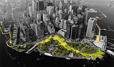
Throughout the ages, while living alongside the Yangtze River, Wuhan people accumulate wisdom and enthusiasm, which has been famous all over the world and passed down through the ages. In the intersection of the two rivers—Yangtze River and the Han River , Wuhan is located in the east of Jianghan Plain, separating Wuhan City into three towns by rivers. There are rivers, lakes and harbors in the city. By the end of 2017, there were 166 large and small lakes in Wuhan. At normal water level, the water surface area of the lakes can reach 803 square kilometers, accounting for a quarter of the city's total area.

Figure 1 Distribution Map of Water System in Wuhan City
1.2 Riverside shoreline characteristics
Riverside area is a special precious space with the most superior urban ecological resources, the deepest cultural accumulation, and the most active urban construction. It is compatible with multiple functions such as ecology, landscape, flood control, transportation, and culture, and has become an important exhibition of urban cultural landscape, and also a popular area for urban economy and land regeneration and development. The waterfront along the Yangtze River in Wuhan has gathered about 1.5 million residents, and has a magnificent river beach landscape with an area of about 600 hectares and a length of 58 kilometers, creating the world's largest ribbon waterfront ecological park that is integrated with the central city. Under the concept of "ecological restoration and urban regeneration", Wuhan riverside area will become the most famous greenway with riverside landscape characteristics, ecological greening characteristics, and hydrophilic leisure characteristics at home and abroad. Taking Hankou River Beach as an example, the river beach has been built with an area of about 50 hectares and a length of 10 kilometers. According to the seasonal characteristics of floods, different levels of landscape platforms have been set up. As a whole, according to the five-level system of "Yangtze River water body, bridges and docks, parks, dikes and roads, and coastal buildings", a multi-level and three-dimensional urban riverside space has been built, taking into account five elements such as water environmental protection, ecological restoration, public space, traffic flood control and coastal buildings interface.

Fig. 2 spatial system of Hankou river beach
1.3 Opportunities high-quality space utilization
Under the background of ecological civilization construction and powerful protection of the Yangtze River in the new period, Wuhan proposed to give weight to the development of areas alongside the Yangtze River, reshape the urban vision by "great river, great lake, and great Wuhan". Based on the Yangtze River, create a world-class urban cultural landscape spaces that displays the culture, ecological characteristics, development achievements and urban civilization of the Yangtze River. By learning from the spatial construction experience of world-class cities, Wuhan Yangtze River Area will build world-class business center with a complex and accessible transportation system, industrial high-end economy, innovative culture, natural and livable ecology, through the guidance of the five construction principles of "transportation, economy, culture, ecology, and landscape". Wuhan has carried out major infrastructure projects such as the two high standard major roads on the left bank and the right bank of the Yangtze River, built a number of cultural tourism projects such as the "urban balcony" and the performance of Zhiyin Cruise Ship, rapidly promoted the construction of key functional areas such as Hankou Riverside International Business District, Hanzheng Street Central Service Core District, Wuchang Riverside Cultural Business District, Guiyuan Area, and Sixin Guobo Area, and efficiently promoted the regeneration actions on old urban areas, old villages, and old factories.
2 Design challenges of Yangtze River waterfront space
2.1 Traffic separates the city from the waterfront space
At present, Wuhan is still in the chaos of traffic in the era of great construction. The riverside area in Wuchang on the right bank belongs to the typical spatial texture of wide roads, sparse road network and street area. The construction of the avenue on the Right Bank Avenue seriously blocks the organic connections between the waterfront and the city. Right Bank Avenue, as an important traffic trunk road linking the major expressways in the city, its busy traffic seriously reduces the accessibility of the waterfront and reduces the safety factor for the public to go to the Riverside Beach Park, especially on peak days such as May Day holidays and National Day holidays, which also has serious security risks. At the same time, the average red line width of Right Bank Avenue is 40 meters, which occupies a lot of waterfront space, making the public activity spaces cramped, and a large number of historical constructions are separated by planned roads, which is not conducive to the protection and inheritance of history and culture and also the improvement of the quality of public areas.
2.2 Flood control facilities and riverside landscape lack of integrated design
The flood control standards of banks and dikes in the riverside area of Wuchang are strict. There is a high-standard continuous box-type flood control wall. At present, the top of the flood control wall is 3-5 meters higher than the surrounding terrace, resulting in the dilemma of people living alongside the river cannot see the river. In the past, the construction form of flood control wall was fixed, which resulted in the single function of embankment and poor waterfront perception; There are some factories and abandoned docks along the waterfront where traditional industries have retired. Because of the privacy of their exclusive dike coastline, the formation of continuous coastline is interrupted, which makes it more difficult to transform the dike into a unified landscape. The public spaces of urban river beach waterfront still gives priority to flood control and safety, and there is a lack of organic transition between the bank and Binjiang Avenue, and the effective use of space is insufficient.
Author: Zhang Zhiqing,Wuhan planning and design Co., Ltd
Source:<https://mp.weixin.qq.com/s/VaY4KLZuiso44d-1z-xhhA>
Translated by Zhang Chenxi
Copyright @ 2014 Urban Planning Society of China
Registration Number:05073892-1
